Hiking Map Poland helps you plan hiking routes and navigate the trail.
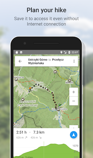
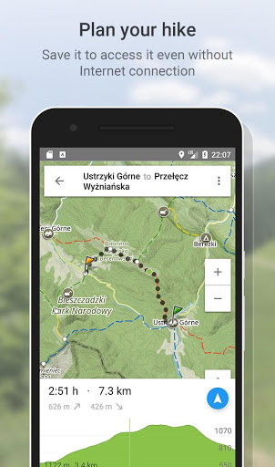
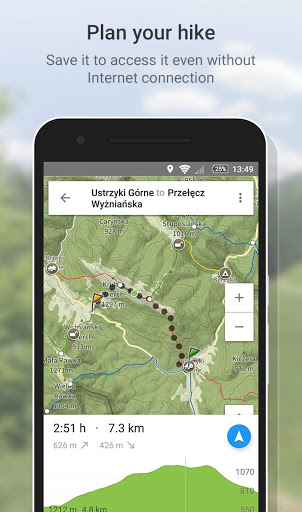
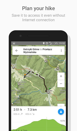
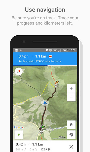
Route planning
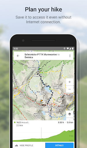
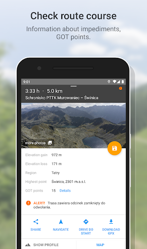
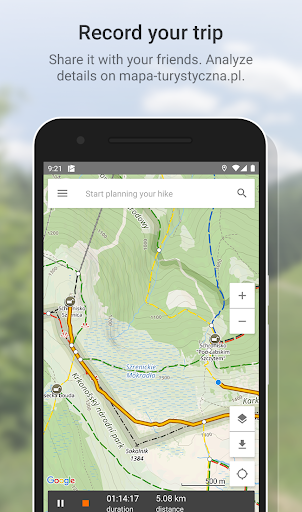
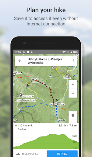
The main functionality is planning routes leading along official hiking trails in the mountains and foothills of Poland. The app finds a route quick and easy, displays it on a map, shows its length, estimated time, detailed course and elevation profile. It also shows your current location.
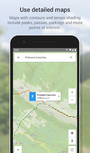
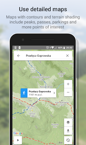
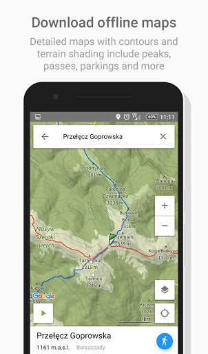
Detailed Touristic map layer with contours and terrain shading contains peaks, passes, parkings and other points of interest. In Premium version user can download maps of regions listed further in this description and use them offline.
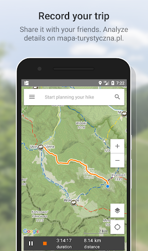
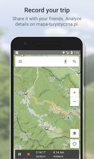
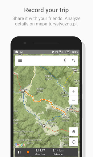
Tracks recording
Second main functionality is recording tracks. You can then share it with your friends!
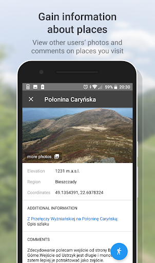
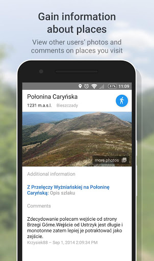
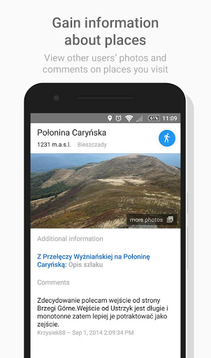
Interesting places
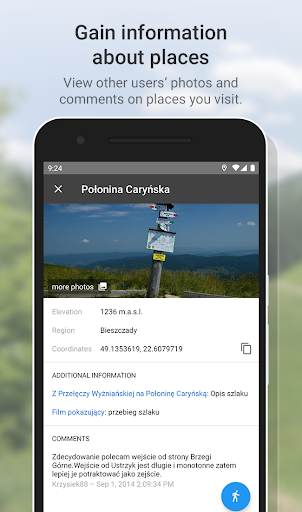
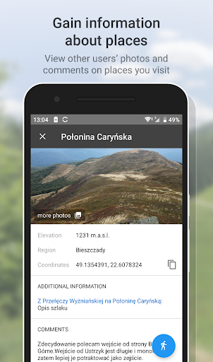
The app also displays information about points of interest: photos and opinions taken from the mapa-turystyczna.pl website.
Detailed functionalities:
- planning routes based on given points; points can be chosen from map or found using the search box,
- intelligent search suggestions, considering spots closest to your location and those most popular,
- displaying routes on a map along with their length, estimated time, route details (spots and trails) and elevation profile,
- information about impediments on route,
- GOT points for planned route,
- showing your current location on the map,
- compass,
- track recording, showing elapsing distance and time,
- list of recorded tracks,
- searching for places and showing them on the map,
- displaying information about places your searched for: photos and opinions taken from mapa-turystyczna.pl website,
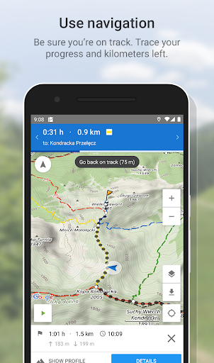
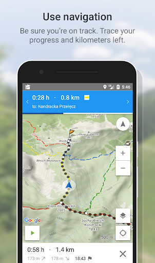
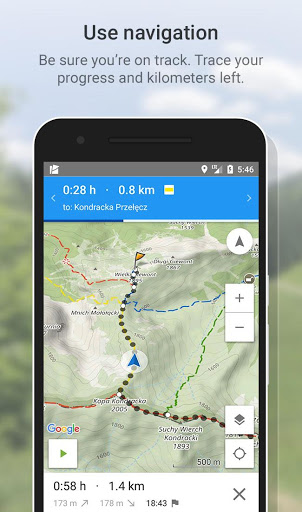
- navigation on planned route,
- detailed touristic maps layer, also available for download.
Available trails from ie regions:
* Beskidy
** Beskid Makowski
** Beskid Mały
** Beskid Niski
** Beskid Sądecki
** Beskid Śląski
** Beskid Śląsko-Morawski
** Beskid Wyspowy
** Beskid Żywiecki
** Bieszczady
** Gorce
* Sudetes (Sudeten)
** Bardzkie Mountains
** Bystrzyckie Mountains
** Orlickie Mountains
** Jizera Mountains
** Kaczawskie Mountains **
Stone Mountains **
Opawskie Mountains
** Sowie Mountains
** Table Mountains **
Wałbrzyskie Mountains
** Złote Mountains
** Bialskie Mountains
** Karkonosze Mountains
** Jelenia Góra Basin
** Śnieżnik Massif
** Rudawy Janowickie
* Sudeckie Foothills
** Izera Foothills
** Kaczawskie Foothills
* Sudeten Foothills ** Ślęża Massif ** Paczkowskie Foothills ** Świdnicka Plain ** Niemczańsko-Strzelińskie Hills ** Strzegom Hills
* Beskidzkie Foothills
** Ciężkowickie Foothills
** Przemyśl Foothills
** Rożnów Foothills
** Strzyżów Foothills
** Dynów Foothills
** Wieliczka Foothills
** Wiśnickie Foothills
* Other
** Wolin Island
** Świętokrzyskie Mountains
** Suchedniowski Plateau
** Kampinos Forest
* * Jura Krakowsko-Częstochowska
** Krakow Gate (Cracow's surroundings)
** Pieniny
Mountains ** Foothills of the Tatra Mountains
** Działy Orawskie
** Tatra Mountains
* Slovakia
** Choč Mountains
** Skoruszyńskie Wierchy
** Kysuce Highlands
** Orava Magura
** Spiš Magura
** Lesser Fatra **
Low Tatra Mountains
** Slovak Paradise
* * Great Fatra
** High Tatra Mountains
App is free. Planning routes and displaying information about places need internet connection. Downloading offline maps and navigation are available in Premium (paid).
1.14.1
- added orientation arrow
- add delete account link
1.13.9
- added keep screen on settings
- fixed location issue on devices with no GPS
1.13.9
- added keep screen on settings
- fixed location issue on devices with no GPS
1.13.7
- fixed issues related to offline maps
1.13.7
- fixed issues related to offline maps
1.13.5
- critical bugs fixes
1.12.6
- updated Google Maps library
1.12.5
- support for Android 12 devices
- fix track recording issue on some devices
- updated external libraries
1.12.5
- support for Android 12 devices
- fix track recording issue on some devices
- updated external libraries
1.11.5
- updated external libraries
1.11.5
- updated external libraries
1.10.7
- Hiking map layer available in free app version
- St. Jacobs's trails
- link to legend
- critical bugs fixes
1.10.7
- Hiking map layer available in free app version
- St. Jacobs's trails
- link to legend
- critical bugs fixes
1.9.5
- support for Android 12 devices
- fixed crash for long routes
- updated external libraries
- critical bugs fixes
1.9.5
- support for Android 12 devices
- fixed crash for long routes
- updated external libraries
- critical bugs fixes
1.8.24
- updated collecting ads consents
- critical bugs fixes
1.8.24
- updated collecting ads consents
- critical bugs fixes
1.8.23
- updated collecting ads consents
- critical bugs fixes
1.8.23
- updated collecting ads consents
- critical bugs fixes
1.8.22
- updated collecting ads consents
1.8.22
- updated collecting ads consents
1.8.21
- support for Android 11 devices
- collecting ads consents
- updated external libraries
- critical bugs fixes
1.8.21
- support for Android 11 devices
- collecting ads consents
- updated external libraries
- critical bugs fixes
1.8.19
- critical bugs fixes
1.8.19
- critical bugs fixes
1.8.18
- route trail types
- navigation bug fix for some routes
- critical bugs fixes
1.8.17
- support for subscription pause and on-hold
- updated external libraries
1.8.16
- fix loading offline maps
1.8.16
- fix loading offline maps
1.8.15
- communiques about impediments on trails
- information about elevation changes on collapsed route panel
- critical bugs fixes
1.8.15
- communiques about impediments on trails
- information about elevation changes on collapsed route panel
- critical bugs fixes
1.8.14
- routes and tracks sync improvements
- changed settings route's completion date
- critical bugs fixes
1.8.14
- routes and tracks sync improvements
- changed settings route's completion date
- critical bugs fixes
1.8.13
- tracking improvements
- location improvements
- critical bugs fixes
1.8.13
- tracking improvements
- location improvements
- critical bugs fixes
1.8.12
- editing route's completion date
- UI/UX improvements for routes list
- fixed navigation issue for some routes
- updated look of recording track's line
- critical bugs fixes
1.8.12
- editing route's completion date
- UI/UX improvements for routes list
- fixed navigation issue for some routes
- updated look of recording track's line
- critical bugs fixes
1.8.10
- critical bugs fixes
1.8.8
- support for Android Q devices
- updated Google Play Services
- fixed issue with showing incorrect current location
1.8.7
- fixed issues with downloading offline maps
- fixed issue with resuming track after save
1.8.5
- fixed gallery issue for some routes
1.8.4
- critical bugs fixes
1.8.3
- fixed elevation gain for planned route
- critical bugs fixes
1.8.2
- changes in planned route UI
- improved copying node's coordinates
1.8.2
- changes in planned route UI
- improved copying node's coordinates
1.7.5
- fixed issue with navigation details
- critical bugs fixes
1.7.4
- support for Android P devices
- copying node's coordinates
- fixed issue with downloading offline maps
- critical bugs fixes
1.7.3
- critical bugs fixes
1.7.3
- critical bugs fixes
1.7.2
- fixed issue with loading Premium state
- UI/UX improvements of Premium activity
- updated Google Play Services
- critical bugs fixes
1.7.2
- fixed issue with loading Premium state
- UI/UX improvements of Premium activity
- updated Google Play Services
- critical bugs fixes
1.6.9
- fixed issue with loading offline maps
- minor bugs fixes
1.6.9
- fixed issue with loading offline maps
- minor bugs fixes
1.6.8
- adjustments for GDPR
- updated About app screen
- UI/UX improvements related to saving routes
- critical bugs fixes
1.6.8
- adjustments for GDPR
- updated About app screen
- UI/UX improvements related to saving routes
- critical bugs fixes
1.6.7
- hiking map layer available online
- groups on offline maps list
- UI/UX improvements
- critical bugs fixes
1.6.7
- hiking map layer available online
- groups on offline maps list
- UI/UX improvements
- critical bugs fixes
1.6.6
- support for Android O devices
- UI/UX improvements related to displaying places details
- fixed issue related to interrupting track recording
- updated graphics with offline maps
1.6.6- support for Android O devices- UI/UX improvements related to displaying places details- fixed issue related to interrupting track recording- updated graphics with offline maps1.6.5- sorting and filters of planned routes- editing route details- exporting routes to GPX file- starting navigation from any point on route- added elevation data for track GPX file- fixed gallery crash for non-existing photos- critical bugs fixes
1.6.4- fixed issue related to downloading offline maps1.6.3- routing from/to any location on trail- fixed issue with vanishing offline maps- critical bugs fixes- changed polyline style for routes- UI/UX improvements
1.6.3- routing from/to any location on trail- fixed issue with vanishing offline maps- critical bugs fixes- changed polyline style for routes- UI/UX improvements1.6.2- free trial period with no credit card required- creating an account on mapa-turystyczna.pl
1.6.2- free trial period with no credit card required- creating an account on mapa-turystyczna.pl1.6.1- critical bugs fixes

 tecno Boom J8